Saturday, August 26, 2017

#Hiking #Dungeness Spit - SaturdaySnapshots

Here's my last post of photos taken during the Auburn Senior Activity Center hiking getaway.

On the way home from Olympic National Park, we stopped to explore Dungeness Spit, located near Sequim, Washington. (Click on photos to enlarge.)


This 5.5-mile-long sand spit juts out into the Strait of Juan de Fuca, the body of water separating Vancouver Island (Canada) and the United States. (See map below.) The spit is home to the Dungeness National Wildlife Refuge.

Piles of driftwood line the shore and provide a good place to sit and enjoy the view.


I zoomed in to capture Mount Baker in the distance and the lighthouse near the spit's end.


We didn't have enough time to walk all the way to the end of the spit and back, but we all enjoyed eating our sack lunches with the swoosh of the waves, salty scent from the ocean, and a glorious view of the Olympic Mountains across Dungeness Bay as our entertainment.


Here's a photo of me in my goofy hat... just to prove I was there!


More info here: Dungeness Spit


Saturday Snapshots is hosted by West Metro Mommy Reads.
To participate in Saturday Snapshots: post a photo that you 
(or a friend or family member)  have taken, then leave a
direct link to your post in the Mister Linky on the host blogsite. 
To enjoy a variety of beautiful pictures from around the world visit

Friday, August 18, 2017

The #Elwha Undammed - Saturday Snapshots

The former site of the Elwha Dam was my hiking group's first stop on the way back home from our Lake Crescent getaway. The dam was built in 1911 to provide cheap electricity for Port Angeles, and it did its job for 100 years. Demolition began in 2012. The result: restoration of the area's ecosystem and critical spawning habitat for endangered salmon species. 
(Click on photos for a closer look.)

Before:

After the dam's removal:

Remnants of the dam were left as reminders of the area's history.


Now the river flows freely from its source in the Olympic Mountains to the Strait of Juan de Fuca. This project was the largest dam removal in U.S. history.

More info about the Elwha Dam:
PBS documentary (about 25 minutes): Undamming the Elwha
National Geographic (3 minutes - time lapse video): Freeing the Elwha


Saturday Snapshots is hosted by West Metro Mommy Reads.
To participate in Saturday Snapshots: post a photo that you 
(or a friend or family member)  have taken, then leave a
direct link to your post in the Mister Linky on the host blogsite. 
To enjoy a variety of beautiful pictures from around the world visit

Friday, August 11, 2017

#Mountains - Hurricane Ridge - #Olympic National Park, WA - #SaturdaySnapshots

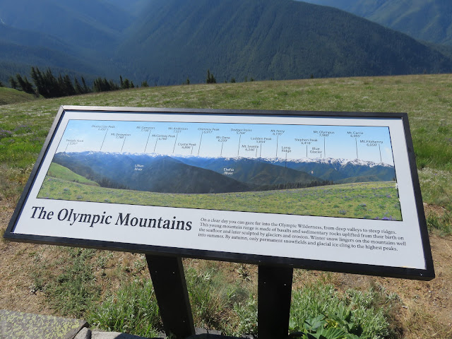
More photos from the July 17-19 hiking getaway with the #Auburn Senior Activity Center. We spent July 18th in the Hurricane Ridge section of Olympic National Park, not far from Port Angeles. Sunny skies, perfect weather with a cool breeze, and dramatic scenery that's hard to beat.
(Click on photos to enlarge)


Tame deer near the visitor center. What a view!
We walked to the top of High Ridge Trail and beyond
View from "You Are Here" on the map above.
See the hikers near the top of the rise?
View across the Strait of Juan de Fuca to Canada.
My cell phone sent me a message saying "Welcome to Canada." 
Break for lunch. Food always tastes better outdoors, doesn't it?
To get to our lunch spot, we hiked along the side of the bare hill on
the left and up past those little patches of  snow in the middle
of the photo. The road into the park is on the right (middle).
Looking back the way we came.

I've posted photos from the rest of our trip here: Waterfalls 
More info about Hurricane Ridge HERE


Saturday Snapshots is hosted by West Metro Mommy Reads.
To participate in Saturday Snapshots: post a photo that you 
(or a friend or family member)  have taken, then leave a
direct link to your post in the Mister Linky on the host blogsite. 
To enjoy a variety of beautiful pictures from around the world visit

Friday, August 4, 2017

#Waterfalls - #Olympic Peninsula, WA - #SaturdaySnapshots

Today's focus is on waterfalls. Recently, I participated in a three-day getaway with the hiking group from the Auburn, WA, Senior Activity Center. We had a fantastic time in the northern part of Washington State's Olympic National Park. For the next few weeks I'll be posting photos from our adventure. (Click on pictures to enlarge.)

Our first destination was Sol Duc Falls (visited on July 17). Trail maps indicated a 5.5 mile round-trip hike via the Sol Duc Falls Trail and Lovers Lane Trail, but our FitBits and other GPS devices showed that we covered 7+ miles. (My FitBit showed a total of 9.3 miles for the day!) We were sure tired by the time we got back to the van! 


A portion of the trail to the top of Sol Duc Falls.

To get an idea of the size of the falls, find the person
on the viewing platform at the right of the photo.
The falls tumble 48 feet into a narrow canyon.
This notice gave us pause!

What a joy it is to walk alongside a gurgling mountain
stream. Wish I could have taken off my boots and soaked
my feet in the icy water.

Ninety-foot-tall Marymere Falls is about 1.8 miles
from our camp at Crescent Lake, WA
This portion of the trail to Marymere Falls
led up a steep narrow path.
Much of our hike took us through old growth forest.
My earlier post about the Nature Bridge facility at Lake Crescent is HERE
More info about Sol Duc Falls and Sol Duc Hot SpringsHERE
and HERE.
Overview of Marymere Falls and Marymere Falls Nature Trail: HERE.


Saturday Snapshots is hosted by West Metro Mommy Reads.
To participate in Saturday Snapshots: post a photo that you 
(or a friend or family member)  have taken, then leave a
direct link to your post in the Mister Linky on the host blogsite. 
To enjoy a variety of beautiful pictures from around the world visit